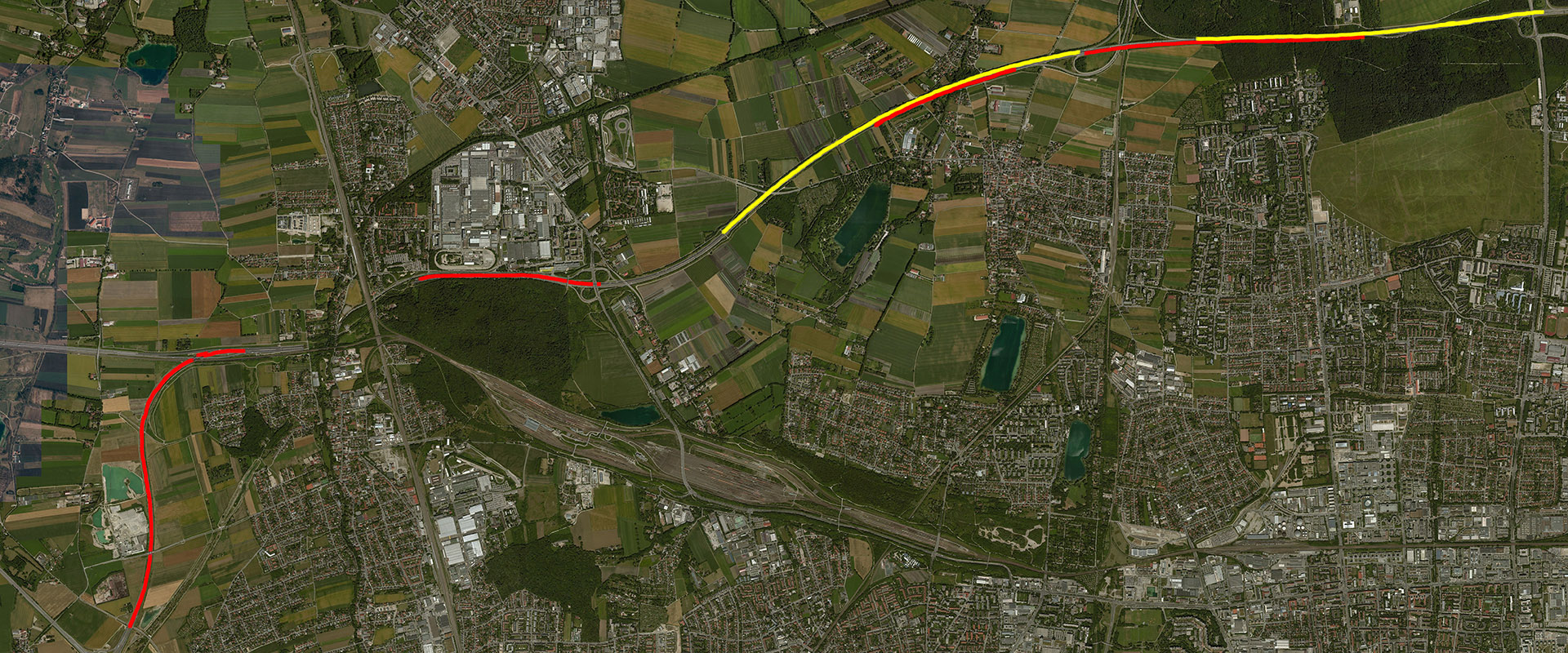
High Precision Lane Model Dataset - Autobahn A99
Download here (2.00 MB)
We collected lane boundary geometry on the Autobahn A99 in Germany, from 48.2206°, 11.5153° to 48.2057°, 11.4586°, divided into seven portions (five for training and two for testing) to exclude overpass structures and other unexpected scenarios.
Please email me if you have any questions!
Description and features
Reference: Lane Boundary Extraction from Satellite Imagery, AUTONOMOUSGIS'17 pdf
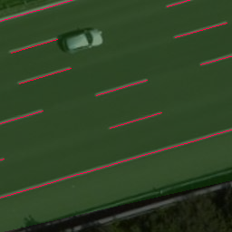
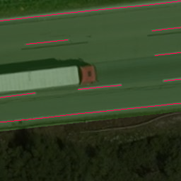
This is a lane-geometry orientated (composed by nodes and links) lane model dataset, compared to traditional mask-like (pixel based) ground truth datasets. The ground truth is manually coded/corrected from the lane geometry generated by our automatic lane geometry extraction pipeline (point cloud based), with inspecting/referring point cloud projection and high-resolution satellite imagery, to make sure this dataset is highly accurate.
Since this dataset is a lane-geometry orientated ground truth dataset, the model can be applied to different satellite imagery sources and level of details (zoom-level) if they are aligned well (mis-alignment is smaller than resolution).
This dataset contains approximately 10.14 kilometers training data and 6.07 kilometers testing data.
Reference: Lane Boundary Extraction from Satellite Imagery, AUTONOMOUSGIS'17 pdf
This is a lane-geometry orientated (composed by nodes and links) lane model dataset, compared to traditional mask-like (pixel based) ground truth datasets. The ground truth is manually coded/corrected from the lane geometry generated by our automatic lane geometry extraction pipeline (point cloud based), with inspecting/referring point cloud projection and high-resolution satellite imagery, to make sure this dataset is highly accurate.
Since this dataset is a lane-geometry orientated ground truth dataset, the model can be applied to different satellite imagery sources and level of details (zoom-level) if they are aligned well (mis-alignment is smaller than resolution).
This dataset contains approximately 10.14 kilometers training data and 6.07 kilometers testing data.
Pros and Con
Image independent: can be applied to different satellite imagery sources and zoom-levels. (this dataset is reusable, traditional mask-like ground truth is disposable)
Highly accurate: has higher resolution than the (current) highest satellite image resolution (~0.15 meter/pixel).
Close to industrial data standard: uses Navigation Data Standard (NDS) like data structure.
Not only geometry: contains other attributes such as types of the line (boundary, dashed line and solid line).
Extra conversion needed: needs to be converted/projected to image coordinate when use it.
Usage
Just load JSON files --> Project points to image coordinate --> Connect the points with same line id --> Then you are ready to go!
>>>Examples:
Just load JSON files --> Project points to image coordinate --> Connect the points with same line id --> Then you are ready to go!
>>>Examples: